Lying
on the Intracoastal Waterway, Hilton Head Island encompasses 42
square miles (68 sq. km) of semi-tropical, Lowcountry geography.
Hilton Head Island's pristine natural environment offers a relaxing,
hospitable atmosphere with subtle signage and no neon lights. Fertile
salt marshes, networks of lagoons and creeks, forests of moss-draped
oaks, magnolias, pines, palmettos and 12 miles (19 km) of sandy
beaches are interspersed with championship golf courses, tennis
courts, fine restaurants and luxurious hotels, resorts and private
villa accommodations.
Warmed year-round by the Gulf Stream, Hilton Head Island's average
daytime temperature is a mild 70°F (21°C). The average annual
ocean temperature is 69°F (20°C)
In 1956, Charles Fraser, son of one of the families that owned Hilton
Head Island, realized that Hilton Head Island had more to offer
than just timber. Armed with vision, energy, modern air conditioning
and investment dollars, he created a master plan for a resort community.
His efforts were aided by the construction of a bridge to the mainland
the same year. Sea Pines Plantation became the prototype of the
modern resort community, now copied around the world.
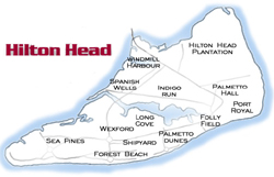
Incorporated as a town in 1983, Hilton Head Island is now home to
several environmentally planned resort and residential communities,
supporting more than 30,000 full-time residents. Most of these communities
have been named "Plantations," but cotton fields have
been replaced by lush green golf courses, tennis courts, shimmering
lakes and beautifully designed resorts and villas. Despite this
development, much of Hilton Head Island remains as it was when sighted
from William Hilton's ship more than 300 years ago. Hilton Head
Island's natural beauty, spectacular seascapes and exceptional ecology
now beckon a new generation of explorers. |
|
Please
click on a map below for more information on each of the
communities:
|
|